CAN: The Whistlers
The Whistlers Trail, Jasper National Park, Alberta, Canada


The Whistlers, standing at 2,470 m above sea level, is a mountain in the Trident Range of the Canadian Rockies. The easiest way to reach the summit is to take Jasper SkyTram to an elevation of 2,263 m and trek all the way up. Take note that the ascent can be pretty steep.
---
CAN: Fairmont Jasper Park Lodge [Visit Only]
CAN: Athabasca Falls
CAN: Columbia Icefield Discovery Centre
CAN: Athabasca Glacier
CAN: Columbia Icefield Skywalk
CAN: Peyto Lake
CAN: Inns of Banff
CAN: Banff Downtown
CAN: Banff Park Museum
CAN: Cascades of Time Garden
CAN: Cave and Basin
CAN: Fairmont Chateau Lake Louise [Visit Only]
CAN: Lake Louise Gondola
CAN: Lake Louise Wildlife Interpretive Centre
CAN: Calgary International Airport
CAN: WestJet WS127 (Economy)
---
After checking out the gift shop and using the washroom at the upper station of Jasper SkyTram, my BFF and I were ready for our trek.
 |
| Learn about the various flora and fauna in the region. |
 |
| Do not feed the wild animals! |
We saw a huge patch of unmelted snow boardwalk.
 |
| The snowy patch was cordoned off. |
 |
| Pika! (o^^o) |
Despite the warning sign not recommending to proceed further, we went ahead to trek as we probably wouldn't have a chance to go there again.
Fit individuals don't really need any special equipment to reach the summit.


Édouard-Gaston Deville of the Geological Survey of Canada called the mountain The Whistlers in 1916 for the whistling inhabitants of the mountain: hoary marmot. We were lucky to see one.


We took a detour to go to the False Summit.


 |
| Wear sturdy shoes that are waterproof or don't get wet easily. |
Édouard-Gaston Deville of the Geological Survey of Canada called the mountain The Whistlers in 1916 for the whistling inhabitants of the mountain: hoary marmot. We were lucky to see one.
 |
| Hoary marmot is the largest North American ground squirrel species. |
 |
| The word 'hoary' refers to the silver-gray fur on the shoulders and the upper back of the animal. |
We'd passed 200 m from the upper station.
 |
| Did someone just stack those stones a while ago? |
 |
| We'd be going to Hotel Fairmont Jasper Park Lodge in the late afternoon. |
 |
| Not many people attempted the trek that day. |
Slightly more than halfway there!
 |
| It was fun stepping on an icy patch |
 |
| What a breathtaking view! |
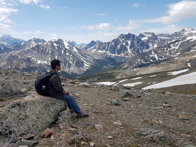
We took a detour to go to the False Summit.
 |
| Pikachu and Melon made it to the False Summit. |
 |
| It looked like we had to pass through that snowy path to reach the summit. |
Here's the last 320 m stretch of the trail to the summit.
 |
| Remember to catch your breath before continuing. |
 |
| Almost there! |
Welcome to the summit of The Whistlers!
 |
| You can continue trekking beyond that point, but there's no distinct trail. The sign says that you need strong footwear, suitable clothing and knowledge of mountain travel. |
 |
| We reached the summit before noon. |
I shall include two panorama shots that I took at the summit.


For someone who's afraid of heights like me, descending the mountain is probably much scarier than ascending it.
 |
| Following the traces made by other people~ |
Below are the last few photos that I took on my way down.
 |
| The upper station looks so small from up there. |
 |
| The river looks silvery from up there. |
The Whistlers is located in a subarctic climate zone with mild summer and cold, snowy winter. precipitation runoff from the mountain drains into tributaries of Athabasca River.


Comments
Post a Comment